BioCycle March 2010, Vol. 51, No. 3, p. 49
Computer models bring new efficiencies and opportunities to compost and energy production, such as mapping feedstock supplies and density, and identifying optimal facility sites. Part I
Craig Coker
IN the organics diversion world, the financial viability of projects hinges on plentiful supplies of raw waste, adequate route density for collection and an optimally located site to minimize hauling distances. GIS tools lend themselves to carefully evaluating that viability. For example, GIS software packages connect attribute information such as quantities of biomass produced, wastes generated, etc. in a database to geographic features such as locations of processing facilities, roads, population densities, etc. on a digital map. GIS models contain spatial relationships between map features – locations of composting facilities and locations of restaurants – and link these map features with lists of attributes about them (e.g., feedstocks accepted, restaurant street addresses) into themes. The models form geospatial databases out of themes, analyzing and extracting information such as how many restaurants are within 50 miles of a composting facility, then create a map of the extracted information.
A GIS can be viewed in three ways:
•Database View: Fundamentally, a structured database that describes the world in geographic terms (i.e., a geodatabase).
•Map View: Set of intelligent maps and other views that show features and feature relationships on the earth’s surface. Maps of the underlying geographic information can be constructed and used as “windows into the database” to support queries, analysis and editing of the information.
•Model View: Set of information processing tools that derive new geographic datasets from existing datasets. These geoprocessing functions take information from existing datasets, apply analytic functions, and write results into new derived datasets.
STATE ORGANICS DENSITY MAPPING
Several states have used GIS over the past ten years to map “organics density” data to support composting infrastructure development. These GIS models map out the locations of organics generators and users (i.e. food wastes and composters, codigestible materials and energy users).
Connecticut Organics Density Mapping Project: In one of the first organics GIS models (2001), the Connecticut Department of Environmental Protection (CTDEP) funded a project that identified, quantified and mapped over 1,300 large-scale commercial and institutional locations in Connecticut where potentially recyclable food scraps are generated, and matched those sources against the state’s transportation network and (then) current composting infrastructure. These businesses include food processors, supermarkets, casinos, military installations, produce terminals and cafeterias in colleges, hospitals and prisons. The project visually illustrates all areas in the state where there are concentrations of generators producing similar types of food scraps, which can be used to plan out locations of new facilities or collection routes.
“Our database is still being used by organics recycling companies looking for logical places to site food residual recycling facilities in Connecticut, not just composting facilities, and by haulers trying to decide where/whether to develop organics collection routes,” says K.C. Alexander, the Organics Recycling Specialist at CTDEP. “One big challenge to anyone embarking on such a mapping project is keeping the data up-to-date.” CTDEP’s report, database and maps are available at www.ct.gov/dep/OrganicsMapping.
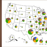
Massachusetts Food Waste Density Mapping Project: The second major GIS study (2002) combined data on nearly 6,000 food residuals generators in Massachusetts with the state Department of Environmental Protection’s (MADEP) GIS system. For each generator, the data includes location information, type of business and the quantity of food residuals that business is estimated to generate (see “Mapping the Density of Food Residuals Generation,” June 2003). This model created the ability to map and show data on all generators within a certain distance of a proposed processing facility. “We set it up so people could download databases of locations of food waste generators and food waste composting facilities into their GIS desktop software,” says John Fischer, Branch Chief for Waste and Toxics Planning at MADEP. “We had some initial challenges with geolocating the facilities due to confidentiality considerations, but developed our own address matching data to avoid those disclosures.”
The state hasn’t done a comprehensive update to the databases since they were created in 2002, but has done periodic partial updates. “What we like about it is the ability to spatially match feedstocks with potential facilities, as well as develop a spatial understanding of the proximity of proposed facilities to major roadways and other facility siting considerations,” adds Fischer. Figure 1 is a view of the map; more information is available at www.mass.gov/dep/recycle/reduce/composti.htm.
Pennsylvania Products and Commodities GIS Tool: The Pennsylvania Recycling Markets Center (PRMC) launched this online tool in 2008. Users can search for facilities geographically and by material type, including (but not limited to) biosolids, brush, food waste, grass, leaves, manure, pallets, sawdust and wood waste. The tool’s integration with Google Maps enables users to zoom in on a facility location, as well as provides contact information and driving directions. Searches are currently limited to organic materials, but other commodities and recycled materials will be added in the future.
Ohio Organics Mapping Project: A similar organics mapping project is under development in Ohio. A sample map from the Cleveland area is shown in Figure 2. “We used Arc GIS as the platform, and all of the data layers are shown on the map,” explains Chris Newman of U.S. EPA Region 5, which helped fund the mapping project. “MSW transfer facilities were listed at the state’s request, as they felt these were facilities that may be accumulation points for organics, from where they would be shipped out to a composter. We included Median Household Income by County to see if there was a correlation between income levels and waste generation levels.”
Joe Goicochea of Ohio EPA explains that his agency’s interest in mapping MSW or food waste only transfer stations is beneficial to states where composting infrastructure is lacking. “In 2007, when food scraps composting discussions really began taking off in Ohio, the entire state was served by only three food scraps composting facilities,” he says. “Since the infrastructure was already established for transfer facilities, then maybe there was an opportunity to utilize these sites to make better use of the existing composting facilities. Since then, we’ve been fortunate to have the number of food scraps composting facilities increase to 17 in Ohio, but other states have seen recent interest from businesses that are considering transfer facilities to launch organics diversion programs.” In most states, a food waste-only transfer facilities would be permitted as an MSW transfer facility. A statewide version of the mapping project is in development, adds Newman, and will include venues, restaurants, supermarkets and a few other fields.
BIOENERGY APPLICATIONS
Not surprisingly, GIS also is being used to plan out organics/bioenergy infrastructure. Several state analyses are described below:
Iowa Anaerobic Digester Mapping Tool: The Iowa Department of Natural Resources (IDNR) developed a GIS-based Anaerobic Digester Mapping Tool to assist the IDNR and its partners with the identification of sites in the state with large quantities of feedstocks for codigestion – as well as industries that are large energy users (see “Converting Waste Streams to Energy and Other Valuable Commodities,” July 2007). Mapping data includes wastewater treatment plants, confined animal feeding operations, open feedlots, food manufacturing facilities, rendering facilities, municipal gas and electric plants, and locations of ethanol and biodiesel production. Interactive maps were created using ESRI ArcIMS software. More information about this interactive tool is available at www.iowadnr.gov/mapping/maps/digester.html.
Washington State Biomass Inventory And Bioenergy Assessment: A similar project was done by Washington State University using a Visual Basic platform (see “Biomass Inventory and Bioenergy Assessment,” February 2006). Essentially, the GIS tool is an inventory of 45 potential sources (field residues, animal manures, forestry residues, food packing/processing waste and municipal wastes) by county. The study showed that Washington State had annual production of over 16.9 million tons of underutilized dry equivalent biomass, capable of producing, via assumed combustion and anaerobic digestion, over 15.5 billion kWh of electrical energy or 1,769 MW of electrical power. About 15 percent of the available biomass was in the form of more readily biodegradable and concentrated waste streams coming from MSW, animal manure and food processing. Mapping of the biomass showed the highest concentrated areas were regions where forestry and municipal or forestry and agriculture intersect, such as the Puget Sound/Cascade and Yakima regions. For more information about this tool, visit www.pacificbiomass.org/ WABiomassInventory.aspx.
Wisconsin Bioenergy Sites and Sources: The Wisconsin biomass mapping project is a website (www.uwex.edu/ CES/cced/bioeconomy/) designed to use information relevant to siting and operating facilities for producing biofuels and energy from sources of biomass in the state (see “Using GIS to Map Biomass Sources,” January 2009). The site includes an inventory of biomass sources with Dynamic Internet Mapping Applications, Biomass Quick Profiles and Feedstock Tables and Bioenergy Map Galleries. The BioEnergy Geospatial Data Server has both Google Maps and Google Satellite View as platforms (see Figure 3, which correlates ethanol and biodiesel producers to soybean harvesting tonnages). The biomass feedstock tables are Excel spreadsheets of the database/geospatial correlation (i.e. dry tons of primary wood product manufacturing residuals by county). Ready-made maps suitable for publication displaying the database and mapping information, in various illustrations, can be downloaded. Categories include Forest Resources and Agricultural Resources.
GIS AS FACILITY SITING TOOL
Composters (and others) are using GIS to find suitable sites for organics facilities. For example, McGill Environmental Systems (www.mcgillcompost.com) is a biosolids and solid waste composting company in the Southeast with two locations in North Carolina and one in Virginia. McGill used ArcView GIS mapping for regional facility development suitability studies in both those states. Layers in the map included landfill tip fees for MSW, C&D and yard trimmings, and locations and estimated waste generation rates for industrial and municipal sources. It was used to identify regions within which siting searches could be done. Figure 4 is an illustration of yard trimmings tip fees in a 50-mile and 100-mile radius around Asheville, North Carolina.
Tracy Myhalyk, who works full-time as a biology professor at Appalachian State University (ASU) in Boone, North Carolina, is using GIS to find a site for a food scraps composting operation for her start-up company, FoodToSoil. “It’s very mountainous and hilly in this part of North Carolina,” she says. “I’m looking for a site based on setback requirements in the state’s regulations for streams, floodplains, residences and wells, as well as one that has slopes of less than 10 percent, is already cleared open or agricultural land and is within either a 5-mile or a 10-mile radius of the center of Boone.”
Myhalyk is using a topography layer to select for gradients less than 10 percent, a land use layer to select for nonforested areas, the buffer subroutine to select areas outside the setback distances, and the radius subroutine to narrow the candidate sites to her desired distances. The spatial intersection of these various layers will provide a list of finalist sites.
A new GIS map produced in Vermont by Stone Environmental for the Central Vermont Solid Waste Management District has the ability to view regional opportunities from a high elevation as well as particular candidate site areas from a lower viewpoint. While the model has many of the same features and datasets of the other models described in this article (e.g., locations of composting facilities, food scraps generators, etc.), one unique aspect is its database of potential areas for siting composting facilities that meet permit criteria. “We conducted a compost site suitability analysis to aid in the location of potentially suitable composting sites,” explains David Healey, the model’s creator at Stone Environmental. “The output is a GIS layer representing areas that may be potentially suitable.”
Available GIS data layers were used to screen out areas that are not suitable due to current regulations and other potentially limiting factors. The screening was broken into two separate parts. The first screening eliminated any area restricted by regulation, which included ground water source protection areas, wetlands, shallow groundwater, shallow bedrock, and proximity to public roads, water bodies and streams. The second screening eliminated any area that could be potentially limiting for a compost facility. This second set of criteria included 100-year floodplains, proximity to housing areas with more than three units per acre, proximity to historic sites, presence of erodible soils, slopes in excess of 20 percent, proximity to endangered species, and sites less than one acre in size.
All criteria screened are included as attributes within the master dataset. Clicking on any point in the map with the “Identify” tool provides information about which potential criteria for composting facilities limited that location. Figure 5 is a screenshot of the model in the vicinity of Burlington, Vermont showing food scrap generators, existing composting facilities (the green circle on the left is Intervale) and potential composting sites (shaded light brown). Further information about the model is available at http://organics.stone-env.com/vtcompostbiogas/bin-release/index.html.
Part II of this article, to appear in the April 2010 issue, covers using GIS in “Spatial Decision Support Tools” for strategic management and improved decision-making, and putting GIS to work in truck routing and to end products marketing.
Craig Coker is a Contributing Editor to BioCycle and a Principal in the firm of Coker Composting & Consulting near Roanoke, Virginia (www.cokercompost.com). He has been using GIS in organics recycling work since 1998. He can be reached at cscoker@verizon.net.
March 23, 2010 | General