BioCycle August 2011, Vol. 52, No. 8, p. 61
Mark Jenner
I am currently helping the California Biomass Collaborative build great California biomass data sets. Recently I was mapping biomass resources for a forthcoming food processing waste assessment that Ricardo Amon has been conducting at the Collaborative. Software technology makes it easy to create maps and graphs without sufficient understanding of the data by the creator or the users.
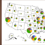
Creating any graphic is a balancing act between exaggerating a data point so it can be seen, and conveying useful information without changing the meaning. My challenge last week was to make a high-volume county-level pie chart fit within the county boundaries, and make the low volume county-level pie charts large enough to be visible. Few readers have a working knowledge of the true scale of these material volumes. For example, it is reasonable to interpret a pie chart that is larger as simply representing a tremendous amount of waste. I just wanted to make the smallest pies large enough to be seen.
Maps are great communication tools, but like any other graphic, they can send unintended messages. Mapping county-level data is a case in point. Counties are a handy unit as a lot of data is available on a county level basis. A difficulty is that the more than 3,000 counties in the U.S. are not the same size. Years ago, to illustrate this, I mapped the counties in the lower 48 states, coding them by size on a square-mile basis. Maryland and Wyoming provide an interesting comparison. They both have 23 counties. Maryland has a land surface area of 9,767 square miles. Wyoming has a land surface area of 97,079 square miles. The entire state of Maryland with its 23 counties is only 10 percent of the land area of Wyoming and could comfortably fit inside the largest Wyoming County of 10,425 square miles. This doesn’t mean that county-level maps are inappropriate. But it does mean that both the map creator and the map reader need to understand the limits.
BIOMASS PER MAPPING UNIT
Several years ago a reputable biomass publication made a claim that North Carolina was a great state in which to invest in manure biomass. This manure investment claim was based on an informative National Renewable Energy Laboratory (NREL) county-level manure methane emissions map, as part of their biomass-by-county series. This map shows half of North Carolina in red (the greatest intensity of mapping unit). The map reader – not the creator – did not understand the information in the map. The first challenge from an investor’s standpoint is that manure does not have a lot of energy in it relative to other biomass feedstocks, so the intense red that signals methane emissions does not translate into “methane energy.” I would not counsel a high return on a manure energy investment based on the NREL manure emission map.
NREL puts out a different version of the county-level map on available residual biomass that reflects total biomass per square kilometer, or tons per (uniform) unit of area. In terms of project investments, this could be a more appropriate tool to use. The available biomass is divided by the uniform land area unit of square kilometers, instead of the highly variable unit of county land area. North Carolina ranks about the middle of the other states for residual biomass intensity. The visible difference between the two NREL biomass maps is that on a strictly county level basis, it appears that a third to half of the U.S. is packed with surplus residual biomass. When it is standardized to uniform units in square kilometers, the compelling biomass counties shrink to about 10 percent of U.S. land area.
In earlier BioCycle columns we have discussed some of the benefits of looking at energy consumption and biomass production on a per capita basis. This is not an automatic success. NREL has made county-level maps on a per capita basis in the past. This is an interesting exercise particularly with residual biomass. Wastewater and municipal solid waste (MSW) are people-centric sources of biomass, while agricultural and forestry biomass are land-centric sources. Mapping people-centric biomass on a land-based map provides some curious results. The highly populated areas have a large denominator and so relatively small per capita biomass, while the agricultural and forested lightly populated rural areas show higher levels of biomass per capita in those counties.
BIOMASS RESIDUALS IN DEMAND
The NREL biomass resource maps are a great place to start when looking at biomass residuals, but the underlying data must also be considered. It is not always easy to define a biomass residual. If a residual is leftover plant products from the production of other agricultural and forestry commodities, then the increased utilization of residuals means there is a constantly shrinking supply. Biomass residuals that are already included in value-added compost or fats rendered into animal feeds are really no longer undervalued residuals.
We are further ahead assigning values to all biomass which include food, feed, fiber, soil amendments and fuel. Once a value-gradient is established based on different market values, then development of new uses and new industries for undervalued organics or biomass is simply a matter of comparing the value of various demands for these materials. Economic success becomes defined by access to the next highest use of value added materials.
Maps and graphics need to be responsibly developed to keep the understanding of appropriate biomass utilization at its highest levels. A compelling resource on this topic is Edward Tufte’s The Visual Display of Quantitative Information. While the title may sound a bit cumbersome, the examples of distorting and clarifying graphics make it an easy read. To have a look at the NREL maps (updated since my analysis above), go to http://www.nrel.gov/gis/biomass.html.
Mark Jenner, PhD, and Biomass Rules, LLC, has joined the California Biomass Collaborative. Burning Bio News and other biomass information is available at www.biomassrules.com.
August 16, 2011 | General