BioCycle January 2009, Vol. 50, No. 1, p. 29
Development of an Internet mapping system to measure local feedstock availability in Wisconsin has applications for biomass utilization projects in any region.
Matt Kures
INDIVIDUALS and organizations in Wisconsin, as in other states, are exploring bioenergy production as a means to enhance economic and environmental well being. Agricultural and forestry industries are looking for ways to add value to their products and decrease waste; Economic development professionals are working with businesses to develop and implement new energy technologies that could aid in growing jobs and income while also reducing emissions; Local governments are exploring the role of bioenergy in lowering operational costs, becoming more energy independent and improving residents’ quality of life.
Despite the interest of these diverse groups, many stakeholders have questions and apprehensions about the feasibility and siting of bioenergy production facilities. There are the more global questions of volatile oil prices and the ongoing “food versus fuel” debate, and the more local questions regarding feedstock availability, transportation infrastructure, the regional labor market and demand for their products. At the same time, citizens and policy makers need information that helps them appreciate the potential fiscal, social and environmental impacts of proposed bioenergy facilities in their communities. Finding ways to integrate entrepreneurial intentions with the needs of the community may help to foster communication, analyze the market and alleviate perceived problems with bioenergy development.
The information needed to answer these types of questions is largely available on the Internet, but much of it is scattered across various state and federal agencies, universities and nonprofit organizations. Furthermore, much of the information is not in a format that can easily answer questions regarding the suitability of locations being considered for new or expanded facilities. Are the necessary feedstocks accessible within an economically viable transportation distance? Where is the energy transmission infrastructure located? How might a proposed bioenergy facility influence the surrounding communities and land? Particularly for large-scale projects, answering these types of spatial questions is necessary to the effective siting, design and operation of a bioenergy facility.
The questions above pertain to any type of organics recycling project being considered or expanded, including composting and anaerobic digestion as well as biofuels. The tool presented in this article has applications beyond bioenergy facilities, as well being useful beyond the State of Wisconsin.
GEOGRAPHIC INFORMATION SYSTEMS
Geographic Information Systems (GIS) provide one means of answering location-based questions and performing spatial analysis. Many industries, government agencies and organizations have used GIS to make informed decisions. Retailers use GIS to find optimal new store locations. Urban planners have applied GIS to model the impacts of urban sprawl. Epidemiologists utilize GIS to map disease incidence and examine possible correlations between environmental factors and chronic illnesses.
While there are as many applications of GIS as there are definitions, geographic information systems are simply software packages that connect attribute information (e.g., volume of waste generated) in a database or a spreadsheet to geographic features that can be represented on a digital map. As an example, consider the location of a concentrated animal feeding operation (CAFO). A GIS can place a CAFO on a digital map using the facility’s street address or its coordinates of latitude and longitude. However, a CAFO also has attributes associated with its location. These attributes could include the type and number of animals at the CAFO, who owns or operates the facility, or the year that the CAFO permit must be renewed.
Different types of geographic information, or themes, can be represented as different map layers in the GIS. In addition to a CAFO map layer, other layers could include the location and attributes of natural gas pipelines, dairy farms, highways, community boundaries or prime agricultural lands. By combining these different map layers, a GIS allows users to ask questions of the data such as, “How many animals are housed at CAFOs within a 10-mile radius of a community?” or “How many CAFOs are located within one mile of a natural gas pipeline?” The answers to these questions can be reported in a simple spreadsheet or text document, but the true power of a geographic information system comes from its mapping capabilities.
For instance, consider an organization exploring the feasibility of a centralized manure digester. The organization may want to see how much manure will be available in different areas, as well as the locations of electrical transmission lines or natural gas pipelines, depending on the goals for energy distribution. A map created with GIS, such as the one depicted in Figure 1, can easily represent this type of information by showing the locations of CAFO permit holders and natural gas pipelines in Wisconsin. The map also shows the results of a GIS-driven analysis that estimates the total number of dairy farms within a 10-mile radius of any location in the state. Consequently, the map in Figure 1 can be used to explore “hot spots” or concentrations of manure sources located near energy transmission infrastructure. Other geographic data layers such as the locations of environmentally sensitive land, watershed boundaries and roads could also be added to the map to help in the siting decision process.
STATEWIDE ONLINE RESOURCE
While geographic information systems can assist in analyzing bioenergy development potential, new and casual users face a number of potential barriers to implementing GIS. Assembling reliable data, high costs for setup and maintenance, and a lack of technical expertise are traditional barriers encountered by individuals interested in using GIS. Recognizing these issues, a consortium of organizations partnered to create Wisconsin Bioenergy Sites and Sources, a website designed to help entrepreneurs, policy makers, community organizations and other groups understand and use information relevant to siting and operating bioenergy facilities in Wisconsin. Developed in cooperation with Wisconsin’s Focus on Energy, the University of Wisconsin-Madison’s Land Information Computer Graphics Facility (LICGF) and the University of Wisconsin-Extension’s Center for Community and Economic Development (CCED), the website provides multiple tools that can be used to explore the spatial or geographic dimensions of bioenergy development:
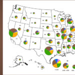
Dynamic Internet Mapping Application is a tool that allows on-the-fly viewing of an extensive collection of map layers relevant to the siting, feasibility assessment and impact analysis of bioenergy facilities. The mapping tool allows users to view data sets depicting feedstock sources and infrastructure locations within various political and administrative jurisdictions (see Figure 2 for a list of data sets). Most of these datasets are derived from state and federal agencies, and many of them are also available for download by individuals with desktop GIS software packages.
Biomass Quick Profiles and Feedstock Tables show the underlying data used to produce the maps. While maps are useful for showing spatial distributions, these tables are valuable for quantifying feedstock amounts in a given region. Furthermore, users may wish to use the data in a tabular format to track trends, perform economic or environmental impact analyses, or produce feasibility studies. Consequently, much of the feedstock information used to create the mapping tools is also summarized in a profile for each county in Wisconsin. Biomass profiles of custom regions in the state can be requested as needed and spreadsheets of selected feedstock sources are also available for download.
Bioenergy Map Galleries meet the needs of individuals wanting premade illustrations, feedstock and infrastructure maps, available for download in several file formats. While the web-based mapping application is useful for viewing different combinations of map layers, Internet mapping does not yet allow for the creation of high-quality maps that can be printed or inserted into documents. These ready-made maps provide state and national perspectives for many of the data sets available in the Internet mapping application. Figure 3 shows an example of a Bioenergy Map Gallery.
OTHER GIS AND DATA RESOURCES
While the Wisconsin Bioenergy Sites and Sources website was developed for Wisconsin stakeholders, a wide variety of free GIS software packages and datasets are available to individuals seeking to integrate geographic information systems into their own bioenergy analyses. In addition to commercial GIS software packages, an increasing number of free geographic information system applications are available on the Internet. Many of these GIS software packages are described at www.opensourcegis.org or www.freegis.org.
Perhaps more important than the GIS software itself is the data needed to create maps and perform spatial analyses. Again, much of this data is free and extensively available on the Internet. The following resources may be of particular interest for bioenergy analysis. Again, these resources can be used by a wide variety of organics recycling projects, not just those focused on bioenergy:
U.S. Census Bureau TIGER (Topologically Integrated Geographic Encoding and Referencing) Files can be used to map geographic features such as roads, railroads, rivers and lakes, as well as administrative areas such as cities, counties and states. The TIGER files can be downloaded in standard formats that are ready to use in many GIS software packages. Visit www.census.gov/geo/www/tiger.
USDA Geospatial Data Gateway allows users to download GIS data sets containing information on soils, water features, elevation, public lands, wetlands, land cover and vegetation types, and roads. The Geospatial Data Gateway also disseminates aerial photography and satellite imagery that can be used in geographic information systems. Go to www.datagateway.nrcs.usda.gov.
U.S. Forest Service Forest Inventory and Analysis (FIA) Program is a continuous forest census reporting information and trends on forest ownership, tree species and growth, wood production and utilization, forest health, and removals by harvest. The Forest Service’s Forest Inventory Data Online (FIDO) tool can be used to download and make on-line maps of FIA data. FIA is at www.fia.fs.fed.us; FIDO is available at: http://199.128.173.26/fido/mastf/index.html.
USDA National Agricultural Statistics Service (NASS) reports annual data on farms, livestock and crop production. While not all data sets are available for every area, NASS provides much of the information for both states and counties. Visit www.nass.usda.gov.
Matt Kures is a GIS State Specialist at the Center for Community and Economic Development, University of Wisconsin-Extension, and presented on this topic at BioCycle’s 8th Annual Renewable Energy Conference in October 2008.
January 25, 2009 | General