BioCycle April 2010, Vol. 51, No. 4, p. 28
Manure management plans, collection route efficiency and targeted product marketing are among the Geographic Information System tools discussed. Part II
Craig Coker
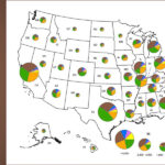
Geographical Information Systems (GIS) have moved mapping from a historical role of provider of input, to an active and vital ingredient in the “throughput” process of decision-making. Part I of this article discussed how a handful of states have used GIS to map “organics density” data to support composting infrastructure development. It concluded with a discussion on use of GIS to evaluate potential sites for organics processing facilities.
Part II discusses additional applications of GIS tools. These include the spatial decision support tool, truck routing and product marketing. Future applications in the organics recycling arena are covered as well.
SPATIAL DECISION SUPPORT TOOLS
A Decision Support System (DSS) is a computer-based information tool developed for supporting the recognition and solution of a complex, poorly structured or unstructured, strategic management problem for improved decision-making. An example of a DSS is in forest management where the long planning time frame demands specific requirements. All aspects of forest management, from log transportation, harvest scheduling to sustainability and ecosystem protection have been addressed by modern DSSs.
When coupled with GIS tools, a DSS often becomes a spatial decision support system (SDSS). An example of a SDSS applied to waste management is the Alabama Poultry Litter Decision Support System (PLDSS). It was developed by Auburn University in 2006 for on- and off-farm management of poultry litter in the Appalachian Plateau and Black Belt regions of Alabama.
Broiler poultry production in Alabama results in about 1.8 million tons of litter annually. Poultry production mainly occurs in the Appalachian Plateau region of north Alabama. As a result, it suffers from excessive land application of litter, resulting in buildup of phosphorus in soils and runoff of pathogens and phosphorus from land application sites. Conversely, the Black Belt region of south-central Alabama has a constrained agricultural economy because of poor soil fertility. Litter produced in the concentrated production areas within the Appalachian Plateau should be better distributed there or transported south for utilization in the Black Belt region.
The PLDSS contains several subroutines to address many of these issues. The Comprehensive Nutrient Management Plan module allows users to develop a quick nutrient management plan and phosphorus-Index calculations. The transportation analysis component allows the user to minimize transportation cost, and the database management subroutine provides for recordkeeping. The transportation analysis will help distribute excess litter within the Appalachian Plateau or the Black Belt regions and also help minimize transportation costs. The net effect is to minimize water quality impacts from land application of litter and to optimize its distribution as a fertilizer at minimal costs.
TRUCK ROUTING
The main application for GIS in waste management operations is truck routing. GIS is used to develop an optimal routing network that minimizes fuel consumption and associated emissions for transporting feedstocks from a network of collection points to an organics facility, i.e., getting the right service to the right place at the right time at the least cost.
The actual algorithm for selection of optimum routings is proprietary in all cases, but is almost certainly a variant in all mapping software of Dijkstra’s algorithm, the fastest way of solving weighted-graph problems with non-negative edges.
The basic idea in this algorithm is to start with a source point and calculate the times to all directly connected points, and then again to all points directly connected to those points, and so on. If a shorter path is found, replace the old path with the new one, until you have the cost of travel to each point in the grid. Every possible route to each point is checked, and you end up with a list of shortest paths to each node from your starting point.
Environmental Systems Research Institute of Redmond, California (now ESRI), makes a GIS model called ArcLogistics™ . It takes into account actual network drive times, distances, street network restrictions, vehicle characteristics, customer characteristics, and more. After solving a routing problem, you can export routes and schedules back to a database using GIS-based applications or print routes with driving directions.
The Miami-Dade County Department of Solid Waste Management in Florida used ArcLogistics to increase the efficiency of specialized routing. One of the programs using the GIS model is dubbed “Go Back”. Citizens leave collection items curbside Mondays and Tuesdays with pickup occurring the following pickup day. Once a year, citizens can request that items such as couches, broken refrigerators, and other larger items be collected. Combined, these programs result in an average of 300 to 600 pickups daily.
During regularly scheduled garbage route service, the county field crews identify locations for specialized pickups. Locations are called in by field crews and are logged in by service staff for next-day pickup. A trash crew is then routed using ArcLogistics for the Go Back service. With this routing tool, Miami-Dade completes in less than an hour a job that once took all day.
In a suburb of Washington D.C., the Fairfax County (VA) Solid Waste Collection and Recycling Department teamed with the county’s GIS office to implement a route optimization software package called “Route Smart”. The goal was to improve the level of service to its 38,000 customer accounts and ultimately reduce the overall cost of collection. Previously, the Department had 16 daily routes for collecting refuse and yard trimmings. Each route was performed using one 10-ton truck and a crew of three. These routes were run first for refuse and then a second time for yard trimmings. They were generally based on number of stops, however the yard trimmings generation varies quite a bit from area to area, which tended to make the routes unbalanced, generating complaints from the crews that the workload was unfair.
RouteSmart can be married to ArcView. The sanitation component was built specifically for the refuse collection industry with database elements that consider such factors as whether a truck can service both sides of the street, the time at the dump or transfer site between loads, the amount of time it takes to service a particular stop, and several others. Local knowledge such as congestion at certain times and avoiding school zones at key hours of the morning is very difficult to program into a computer. The real value of RouteSmart as it was applied to the high-density routings in Fairfax County was not necessarily generating the shortest path for a given route, but rather balanced routes based on time. The county was able to optimize its program and reduce the number of routes from 16 to 10 in the winter and 14 during the yard trimmings seasons.
In European research, a GIS-based model has been developed that takes into account the relief of the terrain to calculate fuel consumption of vehicles that collect and transport MSW to establish an optimal route for collection and transportation. The optimal route is defined as the one that minimizes fuel consumption (not necessarily travel distance). Depending on the slopes of the roads (the gradient), a longer route may be more optimal. Constraints such as speed, truck loading, the time taken to lift collection bins, waste compacting activities and traffic can also be incorporated into these models.
PRODUCT MARKETING, FUTURE APPLICATIONS
Using GIS to map customer locations for tailored marketing campaigns is a relatively straightforward application of this technology. I have used this approach to tailor print advertising and direct mail coupon solicitations to zip codes where existing retail compost and soils customers were based. This information is easily obtained from sales receipts, delivery tickets and written check transactions. (For privacy reasons, customers need to understand that zip codes are the only locational information used.) During the main compost sales seasons, the zip codes from each week’s sales were entered into an Excel spreadsheet, then loaded into an ESRI ArcView model of the region, which had zip code layers along with data on municipal boundaries. Analyzing that data for geographic zip code locations of customers reduced the amount of mailing list data that needed to be purchased, and also allowed print ads to be run in the local weekly newspapers sold in convenience stores.
Another potential use was noted by K.C. Alexander of the Connecticut Department of Environmental Protection: “GIS may have some application in recycling materials exchanges, where a generator and a recycler can access maps of locations, databases of materials descriptions and characterizations, and possibly in routing between sources and end users.” Bob Bylone of the Pennsylvania Recycling Markets Center observed: “A GIS tool can be used as a quick spatial/pictorial way to increase route density for collection of feedstocks. This can lead to reduced material input costs, creating the financial margin required for sale of the final product(s).”
Monitoring environmental parameters is also a logical use of this software. Linking an on-site weather station to a GIS model would enable tracking of weather conditions (wind speed and direction) to predict short-term operational impacts, like odors. David Healey of Stone Environmental offered an intriguing forecast: “I think it could be used to analyze the spatial characteristics of carbon dioxide emissions reductions benefits.”
Four-dimensional GIS (XYZ and time) is the next major frontier. Currently, time is handled as a series of stored map layers that can be animated to view changes on the landscape. Adding predictive modeling to the mix and proposed management actions (e.g., biomass harvesting and subsequent vegetation regrowth) can be introduced to look into the future.
It is clear that GIS technology has greatly changed how we once thought of maps. GIS has moved mapping from a historical role of provider of input, to an active and vital ingredient in the “throughput” process of decision-making. Using these tools will help to develop innovative applications that meet the complexity and accelerating needs of cost-effective organic materials recycling.
Craig Coker is a Contributing Editor to BioCycle and a Principal in the firm of Coker Composting & Consulting near Roanoke, Virginia (www.cokercompost.com). He has been using GIS in organics recycling work since 1998. He can be reached at cscoker@verizon.net.
April 22, 2010 | General